Children’s Wall Map of the United Kingdom and Ireland: Ideal way for kids to improve their UK knowledge
C**.
Lovely map
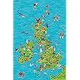
Bought this map along with the Mr Men - The Great British Tour book. Most of the landmarks the Mr Men visited in the book are also shown on the map so it was great fun for my little one to map the journey. Poster was lovely quality and looks good.
T**Y
Amazing value!
I have to say that I was unaware what size this map would be as I didn't notice the dimensions in the description. I was really surprised to find an extremely long carton in my porch and wondered if I'd ordered something in error. No, just a very large map in an even bigger box. The map dimensions are approximately A1 size. It was a little squashed despite the packaging but has soon flattened. The map is clearly printed with the right amount of information for a young child. I will probably mark Colchester on it which is our nearest large town and now has city status. Currently it is in a cheap frame, though the map cost less, waiting to go on the wall in my 3 year old granddaughter's room at my house. I'm really pleased with my purchase.
M**D
Excellent children's map
I bought this as a companion to the delightful Collins children's world map. It is of the same high quality material with charming pictures which make great discussion subjects with not only our 3 year old son but passing adults too. Very happy.
E**S
Nice bright colours
Lovely poster really bright colours and lots of interesting things to look at my 3year old loves it,also very well packaged,arrived in perfect condition.
S**N
Fun and educational
Fun and educational map of the UK and Ireland. My 5 and 8 year olds both like this map and has learnt a lot from it with help from me. We sometimes play little games to see if they can find cities and pictures in it. It has a variety of illustrations and quite a few cities. A map on a wall is a much more powerful educational tool than an Atlas on a bookshelf. The map is cellofane wrapped rather than in a cardboard tube but mine arrived without any damage.There is quite a bit of sea on the map but the map has both Britain and Ireland and all the way up to Shetland Islands. So I think it's difficult to avoid that.There are 14 men and 4 women. I don't think there is any bias here. It's just that Shakespeare, Robin Hood and King Arthur etc are men.It does have a barcode printed on the bottom left corner in vertical orientation. This may bother some although I think it's lot less noticeable than the barcode printed on the Collins World map which we also have.Here is a list of some of the illustrations: Shakespeare, Robin Hood, King Arthur and the Excalibur, Stonehenge, Eden project, Cornish pasties, Angle of the north, Isle of Man TT, Manx cat, Highland cattle, Snowdon mountain railway, Blackpool tower, the Open golf, Wimbledon, Cricket (Lord's/Oval), Rugby (Wales), Red/White rose (Lancashire/Yorkshire), punting in Cambridge, Kilns in Stoke-on-trent, Welsh dragon, giant causeway and more.We all rely on good reviews for online shopping. So if this review was helpful please let me know by clicking the helpful button.
R**N
Fully educational
My six year old granddaughter loves this map, it’s really educational and makes fun learning about Great Britain fun.
I**.
Lovely poster
I got this as a donation for my local school and it looks great. It's perfect for young children to learn about the UK.
R**D
Good quality poster
Fun, colourful, detaled map. My toddler 2.5 year old lives it! Good quality.
Trustpilot
1 day ago
2 days ago