


🗺️ Your pocket-sized trailblazer for fearless exploration!
The Garmin eTrex 30 is a rugged, waterproof handheld GPS featuring a vibrant 2.2" color display, 3-axis compass, barometric altimeter, and over 25 hours of battery life. It supports worldwide basemaps with shaded relief, wireless data sharing via ANT+, and GLONASS satellite reception for faster, more reliable positioning. With 1.7GB of internal storage and paperless geocaching capabilities, it’s designed for millennial professionals who demand precision, durability, and seamless connectivity on every outdoor journey.


| ASIN | B00542NVS2 |
| Additional Features | Compass, Barometric Altimeter, Wireless Sharing, Geocaching Support |
| Are Batteries Included | No |
| Battery Average Life | 25 Hours |
| Best Sellers Rank | #295,479 in Electronics ( See Top 100 in Electronics ) #327 in Handheld GPS Units |
| Brand | Garmin |
| Built-In Media | Two AA batteries, Wrist Mount, microSD card (not included for optional mapping detailed roads) |
| Compatible Devices | Smartphone, Tablet |
| Compatible with Vehicle Type | Bicycle |
| Connectivity Protocol | ANT+ |
| Connectivity Technology | USB |
| Control Method | Touch |
| Customer Reviews | 4.1 out of 5 stars 722 Reviews |
| Display Type | transflective, 65-K color TFT |
| Global Trade Identification Number | 00100177414164 |
| Human-Interface Input | Touchscreen |
| Item Dimensions L x W x H | 4.5"L x 1.3"W x 2.4"H |
| Item Weight | 0.14 Kilograms |
| Manufacturer | Garmin |
| Map Types | Street;Topographical |
| Memory Storage Capacity | 1740 MB |
| Model Name | eTrex 30 |
| Model Year | 2011 |
| Mounting Type | Wrist Mount |
| Operating System | Windows |
| Resolution | 176 x 220 pixels |
| Screen Size | 2.2 Inches |
| Special Feature | Compass, Barometric Altimeter, Wireless Sharing, Geocaching Support |
| Sport Type | Hunting |
| Supported Satellite Navigation System | GPS |
| Touch Screen Type | Resistive |
| UPC | 014444949559 012303519660 172302682847 041114405985 031112101255 617407543216 163120556120 031111717075 097367187291 971478077736 033172662684 086000453466 041114200108 778890545047 088022219891 753759975906 168141455025 100177414164 012303364390 971473532414 617407278033 012302293462 |
| Vehicle Service Type | Bicycle |
| Warranty Description | 1-year limited parts and labor |
R**Z
This is the new eTrex Vista HCx
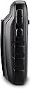
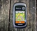
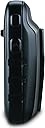
I have just received my eTrex 30 unit, and so far it is perfect and a great improvement over the still amazing eTrex Vista HCx. The eTrex 30 is for all purposes, the new Vista HCx, both have barometric altimeters and both have compasses, however, the 30 has a tri-axis compass that allow to look at the unit perpendicularly to the ground and it will still mark to the north. Among the improvements are of course the new hi-color screen (Allows BirdsEye maps, like having a Google Earth in your pocket on the trail!). Wireless transmission of data via ANT+ that also works with heart rate and cadence monitors. And the most important geek factor, the reception of GLONASS signals! One of the new things that I like a lot is that everything now is a file, on the Vista HCx to download the files it was necessary to use the Garmin serial protocol, now with the 30, only with connecting the unit to a USB port in the computer it is possible to get all the captured data in standard-compliant GPX files. This also means that there is a 2GB (1.7GB usable) flash storage device in the unit. Placing GPX files in the correct folders in the unit also displays the information within those in the unit, like waypoints or tracks. It is much easier now. In Linux I use gpsbabel to convert back and forth from many formats, in particular I enjoy exploring my trips again with Google Earth and it requires KML files, gpsbabel helps to do that precisely. Also, there is an Alarm Clock on the unit, I just tested it a 4:30am and it woke me at about 2 meters from my bed. This is something I really wanted to have in my Vista HCx, as my traveling wristwatch isn't that loud, and I had to use a Casio traveling clock just for that. One less device to carry! Loading maps is now way more faster than with the Vista HCx, having both one for Europe and another locally, takes a few seconds, while before it took minutes As always, a GPS unit like this, now with a GLONASS receiver, will beat any smartphone on trails and while traveling abroad. Here in the tropics close to the Equator I got a fix pretty quick, but not with as many GLONASS satellites as I wished, that is because that GNSS constellation is best used way up in the north hemisphere. The User Interface looks better, with antialiased fonts and pretty icons, it is now more like a Windows XP UI, while in the Vista HCx with its limited color palette, was like a Windows 3.1 UI. The on-screen keyboard seems to be easier to use, and looks like a miniature version of those included in smartphones. Physically, the unit is lighter, more compact (A few millimeters more bulky in depth), easier to handle in your hand, the rocker is in the right side now, good for right handed, but my muscular memory keeps moving my thumb to the previous rocker position in the Vista HCx. The infamous rubber band used in the Vista HCx that unglued so easily with time seems to be substituted with a more solid rubber sides, now attached with screws. The micro SD card is placed like a SIM card in a phone, under the batteries. Now, this is something I have always wanted that was NOT added... An option to LOCK THE BUTTONS! Neither unit has the option to avoid the buttons to be pressed while having the unit on a backpack or in a holster. I would really like an option like in the mobile phones to do that ("Press such and such buttons to unlock"). Many times I have put my units in a bag to later retrieve them in a weird configuration screen and with a track erased or so.
T**S
eTrex 30 is a good little GPS unit
I've had my eTrex 30 for about four months now, I use it primarily for bicycle rides and also for Geocaching and car navigation. I've been holding off writing this review, hoping that Garmin would come up with a fix for a significant problem with the eTrex 30 that others have mentioned. That problem was inaccurate "Total Ascent" calculation (you can see other reviews for more details). Since I base my bike rides largely on how much I climb, I was very disappointed with the eTrex. Fortunately, that problem seems to have been fixed. I'm currently running firmware version 2.80 and the eTrex 30 is now working great, so here's what I like and don't like about it: PROS: -Nice small size, fits into a pocket when not used -Display is very clear, especially in direct sunlight. It is typical of other, non-touchscreen, Garmin handhelds. -Battery life is excellent, I use Kirkland akalines and it runs quite a while on those (almost as long as my old eTrex Vista). I'm sure it would be even better using Li-ion batteries. -It has all the functions (and even a few more) of the Garmin GPSmap 62s for much less money. -It powers up and finds itself very quickly (15-20 seconds) if you are close to where you shut it down. (It can take well over a minute to find itself if you've traveled some distance with it off). -I found it very easy to learn to use. It's a bit of a hybrid between the old eTrex series and the newer GPSmap series. The button functions are similar to the old eTrex series and the menus and functionality are nearly the same as the GPSmap series. Since I've owned both, I had no problem adapting. If you are new to handheld GPS units, it may seem a bit overwhelming at first since it's got so many features, but you'll soon get the hang of it. -There are literally thousands of ways to personalize this unit, you can set up different activity categories (i.e. bicycling, geocaching, car navigating, hiking, boating) and assign pages appropriate to each one (maps, altitude, compass, geocaches, etc). -Good value, you get a lot of functionality for your money. CONS: -The processor can be a bit slow, it often takes a second or two between the time you push a button until something happens. This is the reason I give it four stars instead of five. I've got to admit that I'm somewhat comparing this to my GPSmap 62s, but even if I didn't have the 62s, I think I'd still find the occasional slowness of the eTrex 30 annoying, but still usable. -The display is a bit small. The unit has the ability to cram a lot of info onto a single screen, but sometimes the little characters or graphics are just too tiny. Fortunately, in most cases, you can also spread this info out over several screens (or pages) and use much larger characters. -As others have said time and time again, the base maps this comes with are pretty bad. I've added City Navigator on micro SD card to mine as well as a couple of free topo maps (from GPSFileDepot.com). If you want a Garmin handheld, you just have to live with this. Bottom line: If you want a handheld GPS receiver that does everything very well, I'd strongly recommend the Garmin GPSmap 62s. If you don't want to spend that much, the eTrex 30 does nearly everything the 62s does for a whole lot less and I highly recommend it as well. (In case you are wondering why I have both, I got the eTrex 30 to take on routine bike rides so I don't torture the 62s as much. I also use it as a backup for geocaching and to keep in the car in case I need it. I use the 62s primarily for geocaching).
I**S
Best in Class
Wonderful little device that fits in the palm of the hand. It can use city and topo maps, and is capable of displaying superimposed high resolution (~1 m) satellite imagery. It should be noted that the available Birdseye imagery for Minneapolis is years old and out of date with respect to important buildings. Both Target Field (Twins) and TCF Bank Stadium (Gopher Football), for example, are shown as under construction when they both have been in service for a significant time. With a CityXplorer map of Minneapolis, it provides turn by turn navigation tailored to auto or pedestrian travel - accurately routes me on the complex sidewalks (called "alleys" by the device) 0.6 miles across my large college campus to my favorite wine bar, for example, giving me considerable confidence that pedestrian travel in a strange city would be a breeze. Has many functions and modes to serve specific needs. It is capable of using both GPS and Russian GLONASS satellite systems and ground based correction signals. Outdoor resolution is very good, said by Garmin to be 3 m 95% of the time with activation of ground based correction mechanisms. Functions inside light construction (wood frame houses without metal siding and commercial structures with open architecture and non metallic roofing with reduced resolution (circa 20-40 ft). My device is turned on by my keyboard as I write, inside my wood frame home, and it is showing a resolution of about 35 ft. Were I to walk outside, that would rapidly drop to about 10 ft most of the time. The device maintains satellite lock while walking under heavy metal bridge structures of significant height. Satellite acquisition times when using both GPS and GLONASS appear to be only a few seconds under conditions where satellites will eventually be found. Accuracy improves further over about 30 seconds after satellites are first acquired. I use my device for documenting city walks for exercise and the apparent accuracy when moving is very good, placing the path on or near the sidewalk or trail virtually all of the time, consistently placing the path on the correct side of a city street, for example. Waypoint averaging techniques are somewhat time consuming but accurate. My device converged to no further correction in 9 samples of a few minutes each taken at least 90 minutes apart which resulted in placement of a waypoint very accurately on a spot in front of my home, as indicated by a satellite image overlay. Battery life, using rechargeable NiMH batteries appears to be very good. Because of the complexity of the device and the number of functions available, it is clear from my reading of other reviews that those evaluating the device critically for a specific use may find some glitches, which seem to be continually refined by Garmin. In my limited experience, thus far, turn by turn directions in automotive mode are good but imperfect. When asked to give the quickest route to my local supermarket, for example, it fails to choose the freeway that is parallel to a slower city avenue and there has been one example of a mapping flaw that resulted in a suggested turn the wrong way down a one way street. Product support took my complaint promptly and promised to correct the map in future updates. Documentation and instructions are the weakest part of the package and it takes some experimentation to get a complete understanding of features and options but Garmin customer service is excellent. Overall performance of the small, rugged, waterproof device rates five of five stars. Consider the eTrex 20 as a much more economical option when the altimeter and magnetic compass are not required. I paid the extra $90 or so for those features but, in retrospect, I really do not need them for essentially all of the activities for which I currently use the device.
M**.
Great Little GPS
I bought this mostly for Geocaching, after using a couple smartphones for years. I was looking for better reception and better battery life. This unit does the trick! With fully charged batteries, I can use it over a few days without having to charge batteries again. The Basecamp software is a bit of a pain, but I had no trouble getting some maps onto the GPS with it. I was able to find topo and routable maps for free, and even one that shows trails. This makes the eTrex useful where I have no signal for my smartphone. I still prefer my smartphone for road navigation but the eTrex does great when I need it. I have been able to find free maps for places I have been on vacation pretty easily. I found that I can export GPX files from the c:geo app on my phone, place them on the GPS, and they show up under the list of Geocaches. It even recognized which ones I have already found. Keep in mind this unit is built for durability, not performance. I have used it in wet and rough conditions with no problems. It does not have an HD screen or exceptional graphics power, but it does its job well. The USB takes a while to move large files, and you have to wait a few seconds when scrolling the map around, but I am fine with that. Accuracy has been very good. I wasn't sure how well WAAS would work in my area (NW US), but even with trees and hills around I still get WAAS as long as there isn't a lot of terrain to my south. I get 8-10 feet accuracy in good conditions, and typically better than 20 feet unless I'm under really dense trees or cover. Reception is definitely better than my smartphone. I leave it on GPS+GLONASS+WAAS without issues. I was unsure about WAAS support outside the US, but I had no problem getting WAAS in Ecuador (and the satellites are at the equator, so it should be even easier to get a signal there). The antenna is designed to work best when horizontal, parallel to the ground. However, I can hang it from my bag or throw it in my bag, and it doesn't lose that much accuracy. You would really have to cover it to make it lose signal. I would definitely recommend updating the firmware from what it comes with. Mine did not come with the latest firmware, and they made lots of changes since my version. I have no need for very accurate elevation, the readings I get are plenty accurate for me. You can calibrate it with known elevation or atmospheric pressure. The compass needs to be recalibrated sometimes, but once per day is the most I have needed. For getting me pointed in the right direction, it was worth it for me to get the 20 over the 30 for the compass. I also enjoy having my tracks from my adventures to view in Google Earth. Overall, it's been a great little device.
B**O
Not Bad, But There Are Some Annoying Limitations
I recently purchased a Garmin eTrex 30 for my outdoor needs. Here are some of the annoyances I have discovered about this product. The picture on the box shows a good looking screen with a map and terrain contours that look awesome. But those terrain contours on the basemap are so huge, that if you were out hiking you'll never walk far enough to actually walk around the hills. So you'll have to buy the more detailed map. I bought the Topo USA 100k on DVD, because if you buy the SD cards or download it, you can only use it with one physical GPS device, so if you change to a different device later, you'll have to buy the maps again. That's how I understood it at least. You can't load the entire map on a micro SD card. I bought a 32gb card thinking I'll load everything and just have it in there. But no, you can't do that. First there is a file size limitation of 4gb, which I believe is a FAT 32 shortcoming. 4gb also coincides with about 4000 map sectors, which is a device reading limitation. So even if you can get a file larger than 4gb, you still can't use it because the device won't read it. I thought ok, I'll just load it into different files with different file names, I'll have a western US, eastern US, AK/HI. No, you can't do that either. I spoke to customer support and they said that even if you can get multiple files on the card, it's the total amount of map sectors that count. The device can't be set to use one map file and ignore the others. Loading a map file caused my unit to slow down a lot. Screen redraws are painfully slow now, even when I fly to Europe where my Topo USA doesn't cover. Maps get loaded to the SD card via a software application called Mapinstall, which took over 30 hours to render a continental US map file on my Mac. It would have taken much less if the application was written with multicore processor support, but it wasn't. Didn't get to whether it will even see more than one file. I like to use my GPS when I travel on planes. This particular model has the barometric altimeter, which works great everywhere except inside a compressed cabin. Sure, I knew that, but I also thought they would have put an option to disable the barometer, or just read the GPS calculated elevation and ignore ambient pressure. Turns out they didn't do either. The GPS elevation data exists and is available to be seen on the Satellite page, but every other data field combines it with the barometer reading making it unusable within the confines of a compressed cabin. Now for the nice features. Love the GLONASS capability, but I would like more clarification on how it works. Can the device work solely on the GLONASS system? Also, hypothetically speaking, if it sees 2 GPS satellites and 2 GLONASS satellites, can it calculate a position? Tracking works great, screen is decent but I did expect more, battery life isn't too bad if you ride the backlight low or keep it off. Haven't tried road use, so I can't comment on that. No great circle routing. Am I asking for too much? Bottom line is buy only if you need. Unless you have to have a map you can't load on your older device, it's not worth it.
A**N
Great for hiking with free maps/tracks
I've been using the GPS on my phone for hiking and backpacking for a couple years now. The EveryTrail app is terrific. That said, the phone battery only lasts about 4 hours when used constantly as a GPS, and after hiking with other people using Garmins, I finally bought this Etrex 30. It's light (4.5 ounces with battery), lasts MUCH longer than my phone, and works much better as a GPS. I can now leave my phone off and save the battery. (It's also much easier to read in bright light than my phone is, and unlike my phone, can be easily viewed using polarized sunglasses.) There's a lot of negative comments and reviews here, though, which I'm glad I ignored. No, maps don't come with this unit, but they are easily available for free online at gpsfiledepot.com, good-quality maps with installation tutorials. I fit a topo of California plus two separate overlays of hiking trails into the built-in storage, and I've still got over 1 GB of space left. A microSD slot is available for people who need still more space. You can also find GPX tracks for free on the web which can be transferred to the GPS. EveryTrail, for example, has many high-quality hiking tracks which can be saved as GPX files (from the EveryTrail web site) and then transferred to the GPS using Garmin's BaseCamp software. This is actually now my preferred method of getting trails onto the GPS, with the free California topo as a background. Yes, the instructions are poor to nonexistent, but the menus aren't that hard to figure out if you've used a GPS in some other form. Just walk through the menus and play with it a little. Some default functionality is annoying, but every problem I've had so far was fixable through a setting. (For example, I didn't see place names until I changed the maps settings, and I have no need for constant backlighting, which just drains the battery. The default track color is very hard to read against a topo background, so I changed the color to red.) I agree that they could have included a lanyard, and there's no clip with this thing. For now I carry it in my shirt pocket, but I'll probably attach a carabiner and a cable tie to the lanyard attachment point to make sure it doesn't get lost. This is my first standalone GPS, and I'll probably be figuring more stuff out over time, but given the weight and battery life and accuracy and wealth of free maps, I'm quite satisfied. It's much more reliable than using my phone.
K**E
Read the book & practice with it!
UPDATE July 2013: My daughter carried my eTrex 30 in her school backpack on a field trip on Seattle's Underground Tour. In the late 1800s, Seattle got fed up with tidal flooding of homes and businesses in the low lands near Elliot Bay. The city built new streets and sidewalks one story up, turning what had been the ground floor into basements. The tour took the kids among some of the thickest downtown development, above ground and below. The eTrex recorded a 5.8-mile track that was ragged at times, as its satellite location estimates got a bit imprecise, but there are only a few minor instances of straight segments that indicated the unit had lost satellite lock and regained it later. For a system that's only supposed to work with a clear view of the sky, that's impressive. ----- This is my first GPS, though I've used others on search and rescue missions. The eTrex 30 does a surprising amount of stuff, but it has a bit of a learning curve. I downloaded the owner manual before ordering the unit, and read it all before it arrived. I've used the unit while hiking & driving, and I still keep finding new things it does. It does have some quirks, though, even with the latest firmware (ver. 2.80, downloaded & installed automatically when I plugged it in with BaseCamp running). I chose the eTrex30 over the 20 for its compass and altimeter, but on a hike in the North Cascades the altimeter disagreed with the contour map by hundreds of feet sometimes, even telling us we'd dropped elevation when our legs, our eyes, and our sweat said otherwise. I still haven't learned whether the unit was reporting elevation based on atmospheric pressure or GPS, either of which has its limitations. But the contour map on the screen is easy to read, and you can move the arrow to point at any object or line on the map, and it will display what it is, whether a road or hospital or contour elevation. Satellite sensitivity is over the top. I'd been thinking about buying a GPS for years and read how they can be limited by their view of the sky - heavy tree canopy, deep canyons, tall buildings can all block its view of the satellites it needs. But this eTrex 30 locates itself quickly, locking solidly onto a bunch of satellites, even indoors! It can use Glonass, as well as GPS and WAAS, but on my hike Sunday I limited it to only GPS, on the theory that it might reduce battery drain. A press of the power button when it's already on shows I still have 3 bars out of 4 on my pair of Eneloop AA NiMH cells. (My thanks to Garmin for designing it around AA batteries, which I always carry as spares for my camera, radio, flashight, bike headlight, etc.) I've seen a couple of things others have complained about. After our hike, the trip computer reported that our average speed was about 1.5 times the maximum speed! And while it seems like it's magic that this unit will tell me the tides for any tide station near me, it only reports them once. If I return to the same station's data the area of the screen where the tides had been remains blank. I think I have to turn the unit off & on to see tides again. Strange. Until Garmin fixes that, be prepared to write down any tide info you need. If you're going to use your eTrex 30 in the real world, buy a GizzMoVest and screen protector with it. It will thank you for years.
E**T
A good choice
My 30 arrived a few hours ago. As you read this review, note that Rocker refers to what Garmin has now renamed the Thumb Stick. Pros: o The on-screen keyboard is much better designed than the old eTrex (and this issue was important enough to me to pay for a 450 last year): .....o Stays in upper case (hallelujah) rather than, with the old eTrex, the first alpha triggering the on-screen keyboard to change to lower case and special characters, which then necessitated navigating to the shift character to restore the keyboard to upper case and numbers. .....o DONE is easier to access as are cursor left and cursor right. .....o Can use the Zoom keys (top left side of GPS) to switch between the three keyboards: alpha and numbers, special characters; numbers. o The display is nice and crisp. o Can load maps to internal memory without using an SD card (56MB of maps tested leaves 1.68GB of internal memory). The old eTrex required an SD card . o A distance proximity alert can be created on the 30 using any waypoint or POI as a source (more info below). o Can load maps, waypoints, and routes from MapSource (see Bugs below). o Smaller than the eTrex Legend HCx. o Includes place to affix a lanyard (but a lanyard is not included). o Garmin tech support was excellent. Michael spent and hour and a half as we researched four issues including the bugs mentioned below. o As mentioned by other reviewers, satellite acquisition is fast: first power on to location: 45 seconds. Cons: o The new interface seems cumbersome when compared to the old eTrex. The old interface was quicker to navigate with more data being displayed on menu screens, but maybe it will get better with more hands-on time. The new interface seems to have been designed for a touch screen, which the 30 is not. On some screens, such as the Map Information page there is a lot of wasted empty space. Tip : Use Setup > Page Sequence to add pages that you want to quickly access using the Back button; those pages will then disappear from the Main Menu. o Testing indicates that proximity alerts for POI's loaded using the POI loader do not work. On the old eTrex Legend HCx, POI's containing speed or distance proximity alerts could be loaded using the POI Loader and the Legend HCx would issue the appropriate alerts. The POI Loader works with the 30, but testing indicates that the alert is not issued. This test was for a distance, not speed, alert (speed alerts are of no interest to me, so I'll leave that testing to someone who wants that functionality). On the other hand, proximity alerts can be manually created on the 30 using waypoints or POI's as sources. This is definitely a big Pro and is listed in the Pros above. When the user creates a proximity alert from a POI, a waypoint is created with the same name with a "1" appended at the end of the name. So, it appears that to mass load distance proximity alerts onto the 30 will require loading them as waypoints with the proximity distance set, rather than loading them as POI's. And, it appears that waypoints only support distance alerts, not speed alerts, in the 30, MapSource, and BaseCamp. A minor point: while MapSource can maintain a waypoint's proximity in miles to 3 decimal digits (0.000), the 30 supports only editing to 2 decimal digits (0.00). And, as we all know, 0.01 mile is approximately 53 feet so this is probably a non-issue for most applications. .....o To compound the problem of not supporting proximity alerts for POI's and forcing the use of waypoints instead, Garmin has removed the capability to delete waypoints by symbol, leaving only the choices to (a) delete all waypoints or (b) delete waypoints individually. This means that if I assign special symbols to the waypoints which I want to retain permanently on the GPS while letting temporary waypoints have the default (blue flag) symbol, I cannot delete just the temporary waypoints en masse -- as the old eTrex would have supported. In order to retain the waypoints which I want permanently on the GPS, I will be forced to either a) delete the temporary waypoints individually in the field if I forget to do it at home, (b) remember to delete them in BaseCamp before departing for the outdoors, (c) remember to delete the \Garmin\GPS\Waypoints_dd-mmm-yy.gpx file before departing for the outdoors, or (d) remember to delete all waypoints and then reload all of the permanent waypoints before departing for the outdoors. (I did not realize this until after my initial review submission. I would now give a 4-star rating, rather than 5, because of this whole POI proximity alert issue and the lack of delete-waypoints-by-symbol.) .....o Note that some of the newer Garmin GPS's (e.g., 450) say they support proximity alerts, but the functionality is limited to when a waypoint is on the route being navigated. This is a major difference from the old eTrex Legend HCx, where simply being the appropriate distance from a POI was sufficient to trigger the proximity alert - even when not navigating. In the case of the 30, proximity alerts also work when not navigating (like the old eTrex Legend HCx) but the proximity alert must be for a waypoint and not a POI. o Another new mounting system to purchase mounts for. Bugs: o Cannot transfer tracks and waypoints directly from the 30 to MapSource as was supported for the old eTrex. In USB Mass Storage mode (Setup > System > USB Mode > Mass Storage) only the current track, not waypoints or archived tracks are transferred. In Garmin mode (Setup > System > USB Mode > Garmin), the current track and all archived tracks are transferred but the waypoint checkbox is greyed out in the MapSource dialog box (meaning that MapSource probably does not recognize the waypoint file on the 30). One approach for merging a single waypoint .gpx file and multiple track .gpx files is to drag and drop each .gpx file onto a separate MapSource session then copy/paste into a single MapSource session. For this to work, you would use USB Mass Storage mode. (Note that trying to drag and drop into a single MapSource session results in only the data from the last drag-and-drop being present in MapSource; it assumes replace rather than add and does not issue an error message.) Garmin indicates that BaseCamp is the future and this problem with MapSource will probably not be fixed. o If you download maps to the GPS, the Map Information page will display one of your maps plus the two basemaps which come with the GPS. The Map Information page will not scroll beyond those three maps so you are unable to disable any maps beyond those three. My testing indicates that, regardless, all of the downloaded maps are on the GPS and the maps display correctly; the testing by the Garmin tech support person indicates that the maps were not being displayed properly on his 30 - so we have two conflicting stories. The Map Information page is accessed either by (a) Map > Menu > Setup Map > Map Information or (b) Setup > Map > Map Information. Garmin is working on a fix. Hopefully, all of the parties involved are communicating clearly but I am unsure because Garmin's suggested interim fix did not resolve the problem. The fix was to rename Garmin\gmapsupp.img (the downloaded maps) to any other name, e.g., Wyoming.img. After renaming, the Map Information page continued to display only 3 maps, but rather than displaying the name of a map segment (an area of a larger map set) it was now (after the rename) displaying the name of the map set. Given that I had downloaded 42 map segments from two different map sets, the 30 should be displaying more than one of my maps - regardless of whether it is showing map segments (as the old eTrex Legend HCx does and the 30 did prior to the rename) or map sets (as the 450 does and the 30 did after the rename). o While in USB Mass Storage mode, performing an Eject on Win7 64-bit generates a dialog box: "An error occurred while ejecting ...". So, the 30 does not power down (as the Oregon does) and leaves the GPS's display showing the USB-connected icon. This makes me nervous about whether all files have been properly closed or whether there is potential corruption. This problem did not go away after updating the 30 firmware and rebooting the computer. No other devices are encountering this error. Garmin has no other reported incidents of this problem. I tried different cables (including the included cable), different ports, and three Win7 64-bit computers but the error message always appears. All three computers are running the latest version of BaseCamp (3.2.2), which means the computers have the latest Garmin drivers (2.3.0.0). Tips: o Just like the old eTrex Legend HCx, press and hold Rocker to Mark Waypoint. o Just like the old eTrex Legend HCx, pressing the Power button cycles the brightness: medium > high > off. The user manual just describes pressing the Power button once then using the Rocker to fine tune the brightness level.) o Just like the old eTrex Legend HCx, Menu > Menu will return to the Main Menu. o Just like the old eTrex Legend HCx, pressing and holding the Menu button will open the Find page. o When you first get the 30, back up all of the files on the GPS to a hard drive. o Sometimes it is desirable to display the current time to the second rather than just hours:minutes. This can be useful when setting a camera's time for later automated synchronization of photos to tracks or waypoints. To display the current time including seconds on the 30: .....o Alternative A: Compass > Menu > Change Dashboard > Large Data Field. The time including seconds will appear at the top of the Compass display. .....o Alternative B: set the Trip Computer to Big Numbers and set one of the two big number fields to Time of Day (Trip Computer > Menu > Big Numbers > Menu > Change Data Fields > navigate to top or bottom big number field > enter (Rocker) > choose Time of Day from the list > enter (Rocker)). .....o Alternative C: set the Map to display 1 big number and set that field to Time of Day (Map > Menu > Setup Map > Data Fields > 1 large > Back > Menu > Change Data Fields > enter (Rocker) > choose Time of Day from the list > enter (Rocker)). .....o Alternative D: use the system information page, but the current time will be displayed in UTC/GMT/Zulu time, rather than local time. Turn off the 30 > hold the enter (Rocker) while pressing the Power button > release the Power button > when the system information page appears, release the Rocker. To exit the system information page, power off the 30 as you normally would. .....Unfortunately, using the Power button to bring up the backlight display no longer displays time including seconds as it did on the old eTrex. .....Some of the alternatives above could be implemented using Profiles. o A firmware update (2.10 -> 2.20) is available for the eTrex 30 using BaseCamp or WebUpdater. The update adds support for advanced geocache logging. There is more functionality to experiment with (Compass, Altimeter) but that is for another day.
Trustpilot
2 weeks ago
5 days ago